Navigate every twist and turn with a device built for your passion for adventure

Ultrabright Glove-Friendly 6” Display

Preloaded Topographic Maps With Landmarks

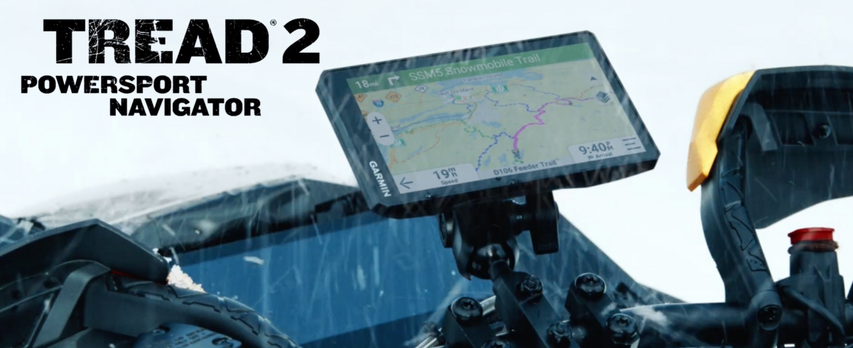
Built For Extreme Weather

Vivid Overhead Views With Satellite Imagery

Premium Maps+ Support (Subscription Required)

Northern U.S. And Canada Snowmobile Trails
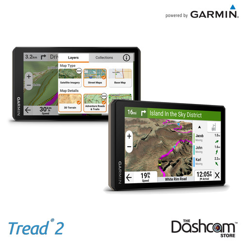
Embark on your next adventure with the Garmin Tread 2, a purpose-built navigator designed for those who seek the thrill of uncharted terrains. Featuring a glove-friendly, ultrabright 6” touchscreen, the Tread 2 thrives in extreme conditions with its IP67 dust and water resistance rating. Whether you're navigating dirt trails, snow-packed paths, or heading back to civilization with turn-by-turn street guidance, this device ensures you'll always find your way. With preloaded topographic maps, access to premium Outdoor Maps+ content, and vivid satellite imagery, you’re equipped with the tools to explore with confidence.
Designed for versatility and reliability, the Tread 2 brings advanced technology right to your fingertips. Track friends with the Tread app’s group ride feature, sync waypoints and routes effortlessly, and monitor your journey with built-in ABC sensors for altitude, compass directions, and terrain angles. From rugged off-road routes to snowmobile trails across the U.S. and Canada, this navigator has you covered. Plus, its powerful processor ensures faster map rendering and route calculations, so you're always one step ahead of the trail.
Stay connected and entertained as you roam with Tread 2's integrated features. Control your music via the built-in media player, access live weather updates, and even pair it with Garmin's GPS dog tracker to keep an eye on your four-legged companions. With over 46,000 public camping locations preloaded and countless customization options, the Garmin Tread 2 is your ultimate partner for the journey ahead.
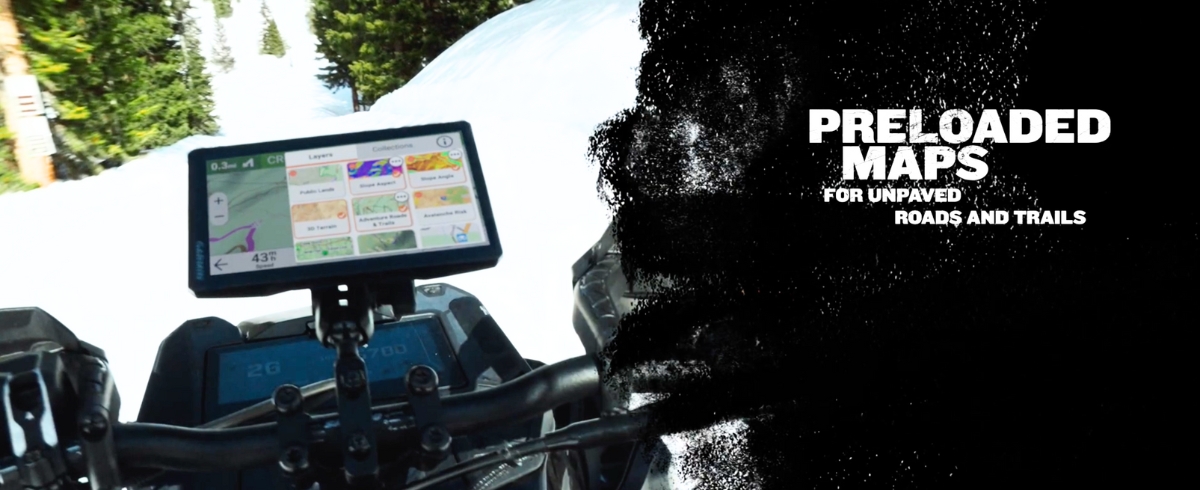
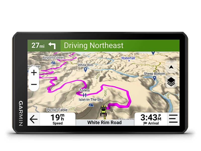
Rugged Design
The 6” ultrabright, glove-friendly touchscreen is ruggedly designed with an IP67 dust and water rating to handle extreme weather and temperatures. Its upgraded processor ensures faster map rendering and quicker route calculations for off-road adventures.
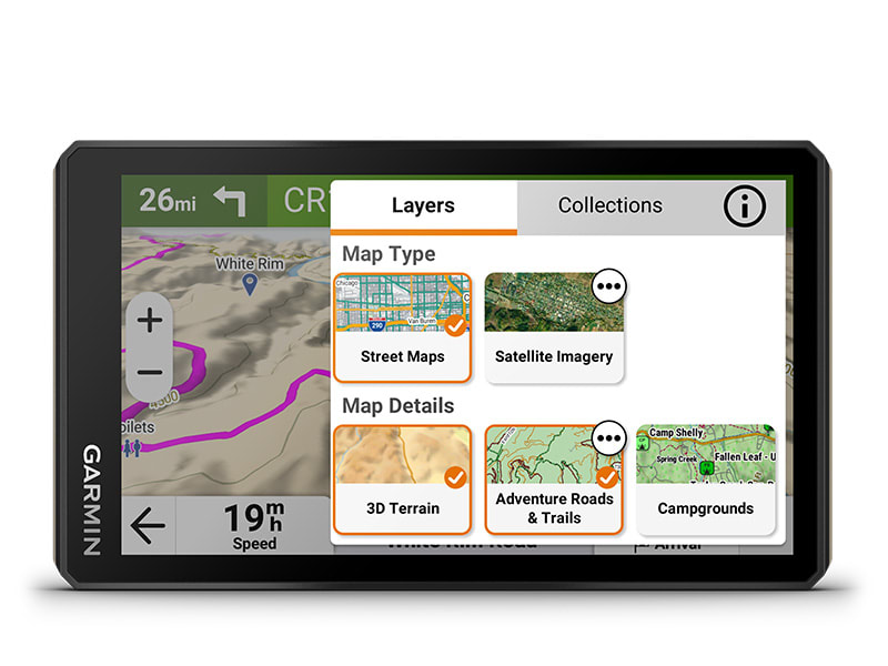
Turn-By-Turn Navigation
Navigate unpaved roads and trails with turn-by-turn guidance using OpenStreetMap™, U.S. Forest Service Motor Vehicle Use Maps, and Adventure Roads and Trails content.
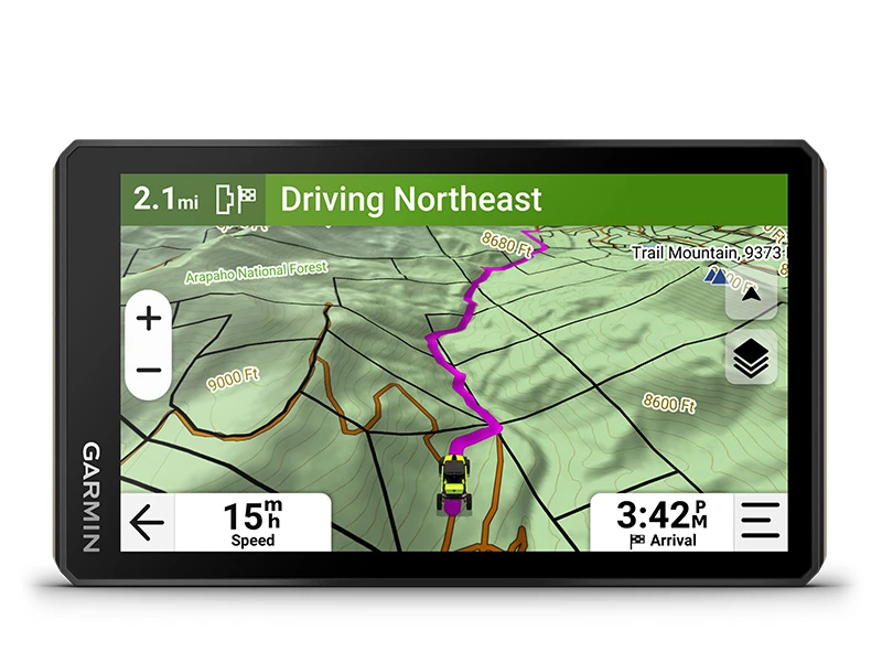
Elevation Maps And More
Explore off-road with HD elevation maps for dirt and snow trails, or stick to the streets with City Navigator maps
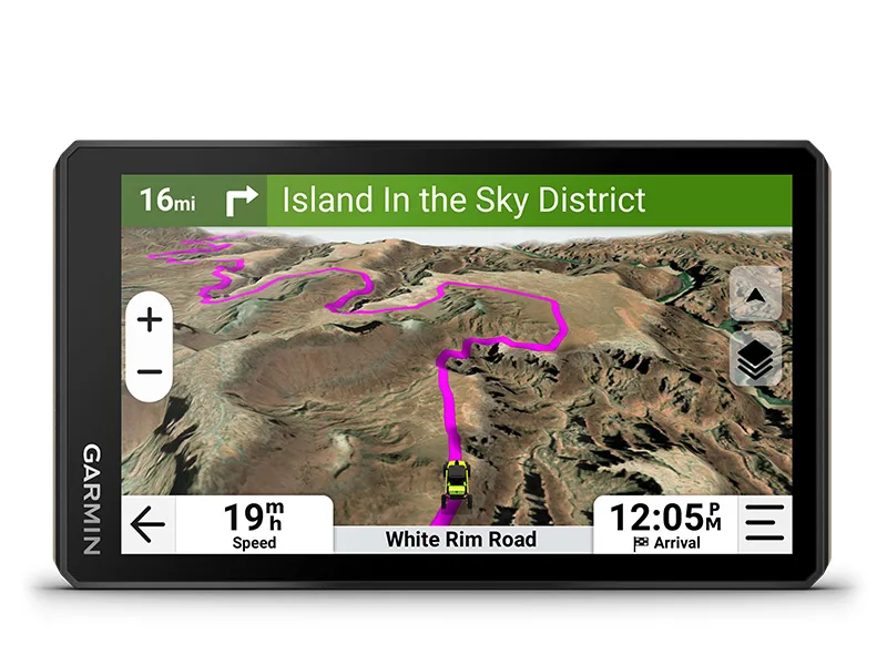
Satellite Views
Download high-resolution satellite imagery via Wi-Fi for detailed overhead views of routes and terrain—no subscription needed.
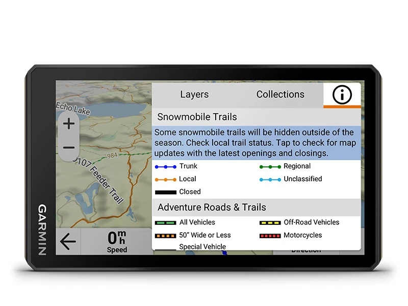
Snowmobile Trails
Access snowmobile trails in select U.S. and Canadian regions, featuring fuel stops, warming shelters, restaurants, and more.
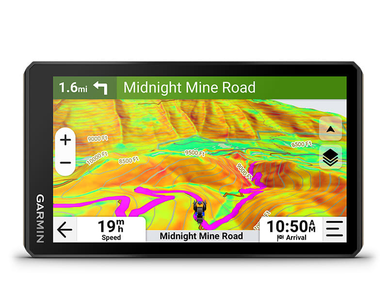
Outdoor Maps+
Get an Outdoor Maps+ subscription for premium map content like slope angles, avalanche reports, and more.
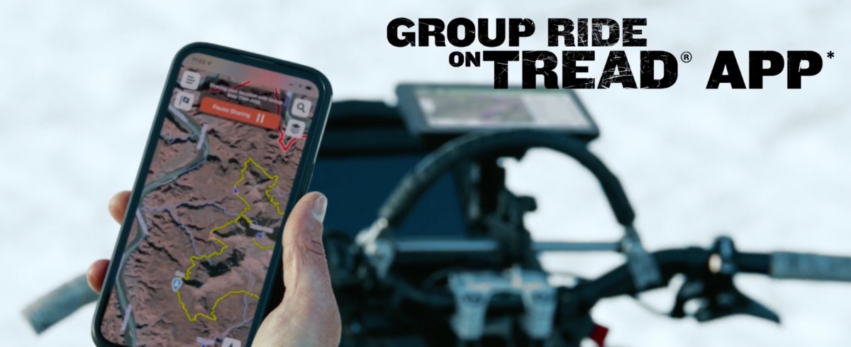

Group Ride Mobile
Track friends from your compatible smartphone or Tread device when you and your friends use the Tread® app’s group ride mobile feature

Sync Your Devices
Sync waypoints, tracks, routes, and collections effortlessly between your mobile device and Tread 2 navigator with the Tread app.

ABC Sensors
Navigate tough terrain with built-in sensors like an altimeter, barometer, compass, and pitch/roll gauges.

Know Your Boundaries
View public land boundaries for national forests, BLM land, wilderness areas, and more, plus private land details for parcels over 4 acres.

Share Your Favorite Routes
Send GPX files from your phone or third-party sources to your Tread 2 navigator and share them with fellow riders via the Tread app.

Go-Anywhere Guidance
Receive spoken turn-by-turn directions and driver alerts for sharp curves, speed changes, and more when using Tread 2 for street navigation.
Dog Tracking
Pair Tread 2 wirelessly with your Garmin GPS dog tracker to monitor and locate sporting dogs in the field, with markers displayed on the map screen.

Live Weather
Stay ahead of the weather by pairing Tread 2 with your smartphone and the Tread app for live weather updates, storm alerts, and animated radar.

Campgrounds
Tread 2 includes a preloaded directory of Ultimate Public Campgrounds, featuring over 46,000 public camping spots across the U.S.

Traveling Music
Control music from your smartphone directly on the Tread 2 display and enjoy it through your Bluetooth®-enabled helmet or headset.
Availability
*** In stock and shipping FREE from Texas now! *** Order today!
Frequently Asked Questions - Garmin Overlander GPS Navigator
| Physical Dimensions | 6.15"W x 3.5"H x 1"D (15.6 x 8.9 x 2.5 cm) |
| Display Size | 5.3"W x 3.0" H (13.3 x 7.5 cm); 6" diag (15.3 cm) |
| Screen Resolution | 1280x720 |
| Display Type | multi-touch, glass, high brightness HD color TFT with white backlight |
| Dual-Orientation Display | ✔ |
| Weight | 12 oz (340 g) |
| Waterproof | IPX7 |
| Battery Type | Rechargeable lithium-ion |
| Battery Life | up to 7 hours (up to 5 hours at 100% backlight) |
| Drop Rating | MIL-STD-810 |
| Tube Mount | ✔ |
| 1" Ball Adapter With Amps Plate | ✔ |
| Preloaded Street Maps | ✔ |
| Data Cards | microSD™ card (not included) |
| 3D Terrain | ✔ |
| Internal Data Storage | 64GB |
| Ability To Add Maps | ✔ |
| External Memory Storage | Yes (256 GB max microSD™ card) |
| Includes Map Updates | ✔ |
| Downloadable Satellite Imagery | Yes (BirdsEye) |
| Topo Map Support | Yes (BirdsEye) |
| Downloadable USGS Quad Sheets | Yes (Outdoor Maps+ Subscription) |
| GPS | ✔ |
| Galileo | ✔ |
| Barometric Altimeter | ✔ |
| Compass | ✔ |
| 10 HZ Multi-GNSS Positioning | ✔ |
| Point-To-Point Navigation | ✔ |
| Preloaded Topographic Maps | ✔ |
| Preloaded US Public Land Boundaries | ✔ |
| Preloaded US Public Land Boundaries | Yes (Parcels greater than 4 acres) |
| Preloaded USFS Roads And Trails, Including Motor-Vehicle-Use-Maps For Motorcycle, ATV, SXS And Full-Size 4x4 | ✔ |
| Navigate-A-Track Navigation | ✔ |
| Turn-By-Turn Trail Navigation | ✔ |
| Compatible With Outdoor Maps+ Subscription | ✔ |
| Backup Camera Compatible | Yes - BC50 (Both Sold Separately) |
| Smart Notifications Via App | ✔ |
| Wi-Fi® Map And Software Updates | ✔ |
| Access To Live Services Via App (Traffic, Weather, Etc.) | ✔ |
| Control music and media from smartphone or MP3 player | ✔ |
| Sunlight readable and weather resistant | ✔ |
| Garmin Adventurous Routing | ✔ |
| Elevation profile | ✔ |
| Round trip routing | ✔ |
| Custom map support | ✔ |
| Wireless ANT+® technology | ✔ |
| Specialized routing for the size and weight of your vehicle | ✔ |
| Speed limit changes | ✔ |
| Easy Route Planner with GPX file sharing | ✔ |
| Garmin Real Directions Landmark Guidance | ✔ | ||
| TripAdvisor Traveler Ratings | ✔ | ||
| Route Shaping through Preferred Cities/streets | ✔ | ||
| Includes Traffic | Yes (with Garmin Drive app) | ||
| Lane Assist with Junction View (displays Junction Signs) | ✔ | ||
| Bluetooth Pairing | ✔ | ||
| Speed Limit Indicator | ✔ | ||
| Pair With Compatible inReach Devices | ✔ |
| Pair With Garmin Powerswitch Digital Switch Box | ✔ |
| Compatible With Group Ride Radio | ✔ |
| Compatible With External Gps Antenna With Mount | ✔ |
| Compatible With External Inreach® Satellite Antenna | ✔ |
| Group Ride Mobile | Yes (With Garmin Tread app) |
| Track Recorder | ✔ |
| iOverlander Points Of Interest | ✔ |
| Ultimate Public Campgrounds | ✔ |
| Pitch And Roll Gauges | ✔ |
| Birdseye Satellite Imagery (Download Via Wi-fi) | ✔ |
| Dog Tracking | Yes (When Paired To Compatible Dog Track System) |
Videos Hide Videos Show Videos
-

Garmin | Tread 2 | Powersport Navigator
Learn more: https://www.garmin.com/en-US/p/1478833. Roam the u...
-

Support: Garmin Tread™ Installation
Garmin strongly recommends having an experienced installer wit...
-

Support: Downloading BirdsEye to a Garmin Tread™
Learn how to download BirdsEye Satellite Imagery to your Garmi...
-

Support: Tread™ Main Menu Overview
Learn what information and features can be accessed from the m...
-

Support: Map Layers on the Garmin Tread™
Learn how to customize what map layers are shown on your Garmi...
-

Support: Viewing Dog Tracks on the Tread®
Learn how to view dog tracks on your Tread® powersport navigat...
Frequently Asked Questions - Garmin Overlander GPS Navigator
| Physical Dimensions | 6.15"W x 3.5"H x 1"D (15.6 x 8.9 x 2.5 cm) |
| Display Size | 5.3"W x 3.0" H (13.3 x 7.5 cm); 6" diag (15.3 cm) |
| Screen Resolution | 1280x720 |
| Display Type | multi-touch, glass, high brightness HD color TFT with white backlight |
| Dual-Orientation Display | ✔ |
| Weight | 12 oz (340 g) |
| Waterproof | IPX7 |
| Battery Type | Rechargeable lithium-ion |
| Battery Life | up to 7 hours (up to 5 hours at 100% backlight) |
| Drop Rating | MIL-STD-810 |
| Tube Mount | ✔ |
| 1" Ball Adapter With Amps Plate | ✔ |
| Preloaded Street Maps | ✔ |
| Data Cards | microSD™ card (not included) |
| 3D Terrain | ✔ |
| Internal Data Storage | 64GB |
| Ability To Add Maps | ✔ |
| External Memory Storage | Yes (256 GB max microSD™ card) |
| Includes Map Updates | ✔ |
| Downloadable Satellite Imagery | Yes (BirdsEye) |
| Topo Map Support | Yes (BirdsEye) |
| Downloadable USGS Quad Sheets | Yes (Outdoor Maps+ Subscription) |
| GPS | ✔ |
| Galileo | ✔ |
| Barometric Altimeter | ✔ |
| Compass | ✔ |
| 10 HZ Multi-GNSS Positioning | ✔ |
| Point-To-Point Navigation | ✔ |
| Preloaded Topographic Maps | ✔ |
| Preloaded US Public Land Boundaries | ✔ |
| Preloaded US Public Land Boundaries | Yes (Parcels greater than 4 acres) |
| Preloaded USFS Roads And Trails, Including Motor-Vehicle-Use-Maps For Motorcycle, ATV, SXS And Full-Size 4x4 | ✔ |
| Navigate-A-Track Navigation | ✔ |
| Turn-By-Turn Trail Navigation | ✔ |
| Compatible With Outdoor Maps+ Subscription | ✔ |
| Backup Camera Compatible | Yes - BC50 (Both Sold Separately) |
| Smart Notifications Via App | ✔ |
| Wi-Fi® Map And Software Updates | ✔ |
| Access To Live Services Via App (Traffic, Weather, Etc.) | ✔ |
| Control music and media from smartphone or MP3 player | ✔ |
| Sunlight readable and weather resistant | ✔ |
| Garmin Adventurous Routing | ✔ |
| Elevation profile | ✔ |
| Round trip routing | ✔ |
| Custom map support | ✔ |
| Wireless ANT+® technology | ✔ |
| Specialized routing for the size and weight of your vehicle | ✔ |
| Speed limit changes | ✔ |
| Easy Route Planner with GPX file sharing | ✔ |
| Garmin Real Directions Landmark Guidance | ✔ | ||
| TripAdvisor Traveler Ratings | ✔ | ||
| Route Shaping through Preferred Cities/streets | ✔ | ||
| Includes Traffic | Yes (with Garmin Drive app) | ||
| Lane Assist with Junction View (displays Junction Signs) | ✔ | ||
| Bluetooth Pairing | ✔ | ||
| Speed Limit Indicator | ✔ | ||
| Pair With Compatible inReach Devices | ✔ |
| Pair With Garmin Powerswitch Digital Switch Box | ✔ |
| Compatible With Group Ride Radio | ✔ |
| Compatible With External Gps Antenna With Mount | ✔ |
| Compatible With External Inreach® Satellite Antenna | ✔ |
| Group Ride Mobile | Yes (With Garmin Tread app) |
| Track Recorder | ✔ |
| iOverlander Points Of Interest | ✔ |
| Ultimate Public Campgrounds | ✔ |
| Pitch And Roll Gauges | ✔ |
| Birdseye Satellite Imagery (Download Via Wi-fi) | ✔ |
| Dog Tracking | Yes (When Paired To Compatible Dog Track System) |

